
Background
IN1302 | |
Litla-Skard | |
Sub-Arctic | |
Open | |
Station | |
Iceland | |
Station | |
1996 | |
Year-Round |
Introduction
Litla-Skard is a monitoring site operated jointly by the Agricultural University of Iceland, the Icelandic Institute of Natural History, the Icelandic Meteorological Office, the Environmental & Food Agency of Iceland, and the Iceland Forest Service. | |
The Litla-Skard long-term monitoring site is located in the lowlands of western Iceland (64°43’ N, 21°37’ W), about 38 km from the shore-line and 100 km north of Reykjavik. | |
The Litla-Skard area exhibits birch shrubs, moss heaths, sedge mires, grassland as well as, sparsely vegetated fell fields. Also a small lake is found within the area. In total, 101 vascular plant species and 19 moss species have been recorded at the site. Birds dominate the vertebrate fauna with 22 species recorded in the area. Most notable of these are whooper swans (Cygnus cygnus), great northern divers (Gavia immer), and redwings (Turdus iliacus) in summer; snow bunting (Plectrophenax nivalis) in winter and raven (Corvus corax) and ptarmigan (Lagopus muta) year around. Three species of mammals occur at the site: Arctic fox (Alopex lagopus), American mink (Mustela vison), and wood mouse (Apodemus sylvaticus). Two species of fish occur in the lake: three-spined stickleback (Gasterosteus aculeatus) and brown trout (Salmo trutta). | |
The Litla-Skard site was designated as a bio-monitoring area in 1996. Litla-Skard is an old, lowland farm. The site is now owned by the Iceland Forest Service. In the past most of the area was used for grazing livestock, mainly sheep. The site has not been grazed since 1985. Afforestation at the site is very limited and disturbance level from human activities is low. The total land area of the Litla-Skard bio-monitoring area is 3 km2 with an elevation of 60-230 m a.s.l. At Litla-Skard there are no research buildings or laboratories, and permanent staff is not located at the site. However, accommodation and laboratory space are available at the campus of the Agricultural University of Iceland in Hvanneyri, 27 km away from the site. | |
Litla-Skard is a national site for the International Cooperative Program on Integrated Monitoring of Air Pollution Effects on Ecosystems (ICP IM). The main research emphasis till now has been on chemistry of precipitation, climate, and hydrology. A vegetation inventory has been carried out at the site, and the main vegetation and soil types have been mapped. The research is mostly confined to a 560000 m2 catchment area. Automated weather and hydrological stations were set up at the site in 2000. Existing data bases include climatic records, data on catchment hydrology and water chemistry, as well as limited biological records. | |
Before the Litla-Skard area was established as a research and monitoring site in 1996, farmsteads and sheep grazing dominated the land-use. Currently there are no farms in the area and domestic grazing animals have been absent for over 20 years. | |
Litla-Skard is reached by car throughout the year. It is located by the main central highway, c. 100 km from Reykjavik. Keflavik International Airport is situated about two hours drive from the site. |
Operator
Icelandic Forest Service (owner) | |
Government | |
Agricultural University of Iceland and Icelandic Meteorological Office | |
hlynur@lbhi.is |
Data Source
Partner Institution
Yes | |
Environment Agency of Iceland, Iceland Forest Service, Icelandic Institute of Natural History |
Location
IN1302 | |
64° 43' 0'' N | |
21° 37' 0'' W | |
European Arctic | |
115 | |
115 | |
229 | |
5 | |
25 | |
140 | |
0 | |
Ice-free ground |
Climate
None | |
High Arctic | |
Snow and Rain | |
740 | |
15 | |
121 | |
NE | |
01/Jan/01 | |
3.1 | |
-1.8 | |
10.8 | |
None | |
April; May | |
April; May | |
May; June; July; August; September; October |
Features
Lake; Mountain; Tree line; Other | |
Polar deserts/semi-deserts; Shrub tundra; Gramminoid tundra; Peatlands; Wetlands; Evergreen forest; Size of drainage basin: 55.5 ha |
Disciplines
Atmospheric chemistry and physics; Climatology; Climate change; Environmental sciences; Hydrology; Limnology; Mapping; Pollution; Soil science; Terrestrial biology |
Human Activities
Yes | |
Domestic animal grazing | |
None | |
Yes | |
No | |
No | |
No |
Infrastructure
IN1302 | |
0 | |
0 | |
None | |
No facilities at site, accomodation at nearby university | |
0 | |
0 | |
6 | |
Yes | |
Yes | |
Renewable | |
220 | |
24 |
Staff Capacity
1 | |
3 | |
1 | |
1 | |
6 | |
0 |
Scientific Equipment
Climate station | |
Free access to baseline data | |
Climate variables, runoff, precipitation and runoff chemistry |
Medical Facilities
No | |
0 | |
0 | |
25 | |
0 | |
0 | |
0 | |
0 | |
No | |
No |
Vehicles
N/A | |
None |
Workshop facilities
ICTS (Staff available to assit with constructions) | |
None |
Communications
Computer; E-mail; Fax; Internet; Printer; Scanner; Telephone |
Access
IN1302 | |
Land |
Aircraft landing facilities
0 | |
0 | |
0 | |
Yes |
Transport and freight
Car | |
None | |
0 | |
N/A | |
0 |
Access To The Facility
None | |
Yes | |
hlynur@lbhi.is |
Pictures
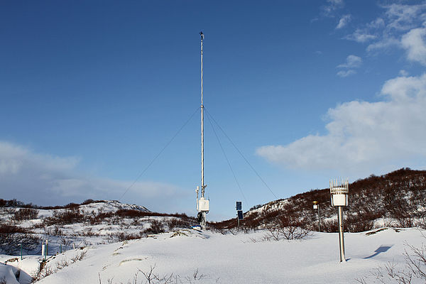 Measuring mast - winter (Credits: Hlynur Oskarsson) |
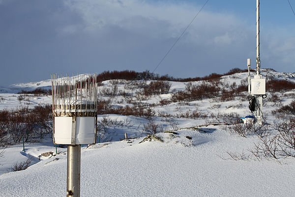 Measuring station - winter (Credits: Hlynur Oskarsson) |
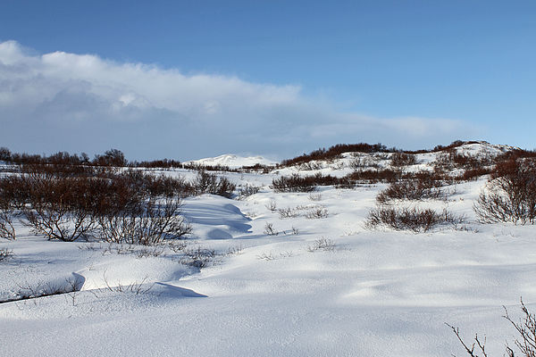 Winter landscape (Credits: Hlynur Oskarsson) |