Background
Signy | |
https://www.bas.ac.uk/polar-operations/sites-and-facilities/facility/signy/ | |
Sub-Antarctic | |
Open | |
Station | |
United Kingdom | |
None | |
1947 | |
Seasonal |
Introduction
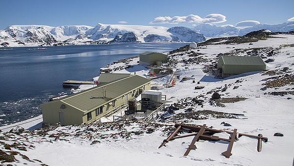
Signy, British Antarctic Survey (BAS) | |
Signy research station is located on the South Orkney Islands. | |
Approximately half the island is covered by a permanent ice- cap, although the highest point, Tioga Hill, is a rock outcrop in the middle of the ice. The ice-cap descends to the sea via two glaciers: the McLeod is by far the largest and terminates in an ice-front along a large part of the south coast; the Orwell is much smaller and terminates in Shallow Bay to the east. The east and west coasts are generally ice-free during summer. The glaciers and ice elds on Signy are in a period of retreat as a result of rising temperatures, and new areas of rock are being exposed every year. The rest of the Island is covered in lakes, of which there are 16, and snow-free ground in summer, which includes steep mountain slopes, mud ats as well as higher ground with extensive moss banks. The ora of Signy Island is largely cryptogamic. Only two owering plants are found: the Antarctic hairgrass and the Antarctic pearlwort. Both of these are restricted in distribution, usually being con ned to shelte | |
Scientific research started on Signy Island in 1947 when a three- man team occupied a site in Factory Cove above the old whaling station. A new hut (Tønsberg House) was built in 1955 on the site of an old whaling station.
| |
Penguin, seabird and seal biology, limnology and terrestrial biology related to the Southern Ocean ecosystems and climate change. Long-term monitoring, in particular for the Committee for the Conservation of Antarctic Marine Living Resources (CCAMLR). Microclimate records exist for various sites on Signy Island going back over 25 years. Much of the data has been collected to support specific projects but now only one station is installed on Jane Col, one of the more extreme habitats on the island with only sparse vegetation comprising mosses and lichens. This type of site is expected to show the greatest response to predicted climate change. The present microclimate station, installed in January 2007, transmits data back to the British Antarctic Survey (BAS) once a week via the Iridium satellite network. | |
Station been present since 1947. | |
Access via sea twice per year. |
Operator
British Antarctic Survey | |
Government | |
British Antarctic Survey (BAS) | |
Data Source
Partner Institution
No |
Location
CO2806 | |
60° 42.4972' 0'' S | |
45° 35.7233' 0'' W | |
Antarctic Peninsula | |
2 South Orkney Islands | |
5 | |
0 | |
Ice-free ground |
Climate
Discontinuous | |
Maritime Antarctica | |
Snow and Rain | |
N | |
-2.2 | |
1.7 | |
1.4 | |
0.2 | |
-1.6 | |
-2.3 | |
-6 | |
-7.7 | |
-6.6 | |
-11.2 | |
-2.6 | |
1.3 | |
0.8 | |
11.2 | |
-30.1 | |
January; November; December | |
January | |
None | |
February; March; April |
Features
Coast; Crevasse; Hill; Ice cap or glacier; Lake; Melt streams; Moraine; Mountain; Permanent snowpatches; Rock; Sea; Sea ice; Seal colonies; Shoreline; Snow; Valley |
Disciplines
Climate studies; Geology; Limnology; Microbiology; Soil biology |
Human Activities
Yes | |
Station been present since 1947. | |
None | |
Yes | |
Yes | |
Yes | |
Yes |
Infrastructure
CO2806 | |
0 | |
0 | |
Biology | |
Rough laboratory, analytical laboratory | |
8 | |
yes | |
yes | |
Fossil fuel | |
240 | |
24 | |
no |
Staff Capacity
8 | |
6 | |
0 | |
0 | |
8 | |
60 |
Scientific Equipment
Autoclave, fume hood, ashing oven, analytical glassware, magnetic stirrers. |
Medical Facilities
Yes | |
8 | |
Non-medical trained person | |
0 | |
0 | |
No | |
No |
Vehicles
None | |
Two skidoos |
Workshop facilities
Mechanical; Wood workshop |
Communications
Computer; E-mail; Internet; Printer; Satellite phone; Telephone; VHF |
Access
Sea |
Aircraft landing facilities
0 | |
No |
Transport and freight
Ship | |
None | |
2 | |
March; November; December | |
Pier/Jetty | |
Beach landing for RIBs | |
0 | |
None |
Access To The Facility
Pictures
 Signy station |