AWI polar research aircraft fleet and associated infrastructures
AWI operates two research aircraft, the Polar 5 and Polar 6 (Figure 5), which are largely identical:
Basler BT-67 (DC-3T) | |
|---|---|
Aircraft Registrations | C-GAWI, C-GHGF |
Range | 3,000km |
Cruise Speed | 100 m/s (200 kts, wheel gear only) |
Survey Speed | 72m/s (140 kts) |
Crew | 2 Pilots |
Mission scientists (max) | 6 |
Fuel Consumption (planning) | 570l/hour |
Max Take Off weight | 13600 kg (30,000lb) |
Survey power available | 550A (28V) |
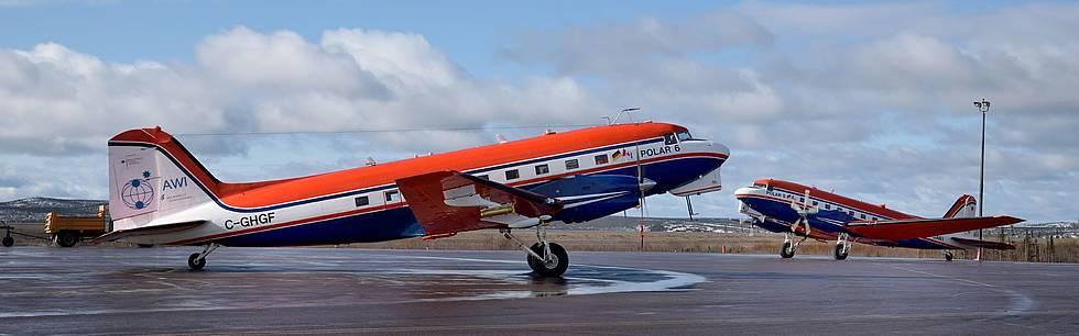
Figure 5 - Polar 5 and Polar 6, the two polar research aircrafts operated by AWI
The personnel involved
Crew: 2 pilots and 1 mechanic
Science support during surveys on site: 2 engineers/technicians
Science support for integration of new instruments by team of several engineers
Operator on board during survey flights: max. 6
PAX on board for transit flights: max. 18
The scientific equipment available on board (AWI owned and external instruments)
Data acquisition system ADA (central data storage and time reference for stand-alone systems)
laser scanner/altimeter: Riegl VQ-580, Riegl LMS-Q680i, Riegl LD90, Astech LDM301
ice penetrating radar systems: ice thickness radar, accumulation radar, snow thickness radar, ultra-wideband depth sounder (24 channel system), microwave ultra-wideband snow radar
magnetometer: Scintrex CS-3
Gravity meter: ZLS, GT-2a
GPS: Novatel, Javad
Cameras: Canon SLR, video, GoPro
Hyper spectral camera: Specim AISA Eagle
Hygrometer CR2
Licor 7200 humidity sensor
Nezerov probe
Thermeter: PT100
Radiation thermometer KT19
5-hole probe with absolute and relative humidity, AIMMS20, AIMMS30
Aerosol lidar AMALI
Methane sensor Los Gatos RMT200
Radiation sensors: Ocean optics (long & short wave) Kipp&Zonen pyranometer & pygeometer
Single particle photometer SP2
Ultra high sensitivity aerosol spectrometer
Sun photometer
Drop-sonde launch system AVAPS lite
PMS cannisters
EM bird (for mapping sea-ice thickness)
ALABAMA (MPI Mainz-owned aerosol mass spectrometer)
ASIRAS (ESA-owned radar altimeter)
EMIRAD-2 (DTU-Copenhagen owned polarmetric radiometer)
The type of science supported
Monitoring and recording interactions between the Earth’s crust, ice- and snow-covered areas, oceans, and the atmosphere:
Mapping of the Earth’s magnetic and gravity field for tectonic studies
Mapping of ice thickness and internal structures of ice shelves, ice sheets, and glaciers for mass balance studies, input and reference data sets for ice dynamic modelling studies
Mapping of sea ice thickness, snow thickness on sea ice, and surface morphology/altimetry for calibraction and validation of satellite derived remote sensing data
Measuring in-situ and remotely of aerosols and trace gases for process studies and input and reference data sets for modelling studies
Measuring of radiation, temperatures, humidity, and turbulent fluxes for process studies and input and reference data sets for modelling studies of the planetary boundary layer
Optical remote sensing for mapping biodiversity in the Wadden Sea and land cover disturbances related to permafrost thaw
Besides scientific operations, the aircrafts are maintaining logistics between different international research stations in the Antarctic, where the AWI is an active member of the international Dronning Maud Land Air Network (DROMLAN).
The AWI strategy in terms of aircraft in polar regions in the next decade
As in the past, in the forthcoming years AWI aircraft will be operating in Antarctica, as well as in the Arctic in each season. The aircraft will be used for scientific expeditions and for logistic tasks in order to support science. The home base of the aircraft is Bremen Airport. The available instrument suite is constantly expanded to meet the requirements by the science community.